top of page


A Nature Guide's -
Guide to the Wet Tropics
Vegetation Communities
The Wet Tropics vegetation mapping comprises a series of fifty-five 1:50,000 maps and recognises 250 distinct vegetation communities in the Wet Tropics Bioregion based on their structural and floristic chararacters.
The Authority has designed a logical, hierarchical framework and map key which groups the 250 vegetation types into ecological communities and identifies relationships among them.
The vegetation mapping is based on the interpretation of 1:25,000 aerial photography of the Wet Tropics Bioregion. Consultants Peter Stanton and David Stanton provided the primary dataset which included line-work marked directly onto aerial photographs and a code unit for each polygon describing its vegetation type based on canopy features from photo interpretation and detailed floristics from field sites.
Source: Wet Tropics Management Authority Web Site
Scroll
Down &
Click on
an Image
 Calophylum Coastal Forest |  62aTall Golden Penda closed woodlandMcLeod River 62a Variable medium to tall open to closed Tristaniopsis exiliflora woodland +- Xanthostemon chrysanthus +-Melaleuca leucadendra +- Grevillea baileyana +- Grevillea hilliana +- Blepharocarya involucrigera +- Atractocarpus fitzalanii fitzalanii +- Millettia pinnata | 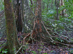 1a Complex mesophyll vine forestMossman Gorge 1a Complex mesophyll vine forest (on deep fertile soils).Very wet and wet lowlands and foothills mainly on basalts and alluvium. |
|---|---|---|
 Simple microphyll vine-fern thicketThornton Peak 17a Simple microphyll vine-fern thicket. Very wet (± cloud) highlands on granites. |  14Simple Microphyll Vine Fern ForestMt Lewis 14a Simple microphyll vine-fern forest. Moist to very wet (± cloud) highlands on granites, metamorphics and rhyolites. |  Mesophyll vine forest with Fan PalmCape Tribulation 2 d Mesophyll vine forest characterised by Barringtonia racemosa +- Hibiscus tiliaceus +- Heritiera littoralis +- Archontophoenix alexandrae Licuala ramsayi prominent in the sub-canopy (seasonally inundated swamps). Very wet lowlands on alluvium. (subtype of 2a) |
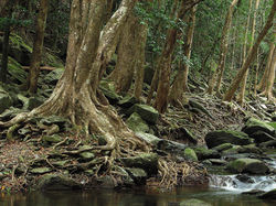 62aOpen to closed Water Gum WoodlandSpring Creek 62a Variable medium to tall open to closed Tristaniopsis exiliflora woodland +- Xanthostemon chrysanthus +-Melaleuca leucadendra +- Grevillea baileyana +- Grevillea hilliana +- Blepharocarya involucrigera +- Atractocarpus fitzalanii fitzalanii +- Millettia pinnata | 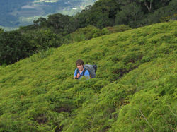 65b Dicranopteris linearis fernlandsTrail to The Pinnacle 65b Dicranopteris linearis fernlands Gleichenia dicarpa Gahnia sieberiana Schoenus melanostachys ± emergent or scattered shrubs. Moist to very wet uplands and highlands mostly on granites. |  2a Mesophyll vine forest.Mossman Gorge 2a Mesophyll vine forest. Very wet to moist lowlands to uplands on a variety of geologies. |
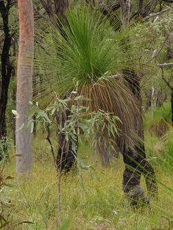 24a Medium Corymbia citriodora woodlMt Spurgeon 24a Medium Corymbia citriodora spp.citriodora Woodland Eucalyptus portuensi+-, Corymbia intermedia +-, Syncarpia glomulifera subsp glomulifera+- Eucalyptus drepanophylla+- Xanthorrhoea johnsonii+- |  Mangrove Cedar Bay.Cedar Bay 70a Medium closed mangrove forest and shrubland mosaic. Species may include Rhizophora spp.,Bruguieras pp., Avicennia spp., . (species zonation determined by soil salinity and frequency of tidal inundation). Moist to very wet lowlands on (saline to brackish) alluvium. |  Simple Microphyll vine-fern thicketThe Pinnacle 17a Simple microphyll vine-fern thicket. Very wet (± cloud) highlands on granites. Dominated by Mountain tea tree (Leptospermum wooroonooran) |
 Simple Microphyll vine-fern thicketMount Lewis 17a Simple microphyll vine-fern thicket. Very wet (± cloud) highlands on granites. | 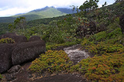 66c Shrubland/heathland complexMt Pieter Botte 66c Shrubland/heathland complex +Allocasuarina littoralis +Syncarpia glomulifera glomulifera+ Lophostemon confertus +Banksia aquilonia Leptospermum+ Borya septentrionalis (on mountain rock pavement).Very wet to dry foothills to highlands on granites and rhyolites. |  10k Simple notophyll vine forestMt Sorrow 10k Simple notophyll vine forest (shallow soils and severe drainage subject to wind shearing in exposed situations). Moist to very wet uplands and highlands on granites and metamorphics. (subtype of 10a) |
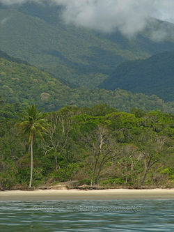 Veg Transect 64a,2b,1a,10a,14a,17aThornton Beach 64a Beach forest complex Variable open to closed shrubland, grassland and low to medium woodland. 2b Mesophyll vine forest. Very wet lowlands on dunes. 1a Complex mesophyll vine forest 10a Simple notophyll vine forest. 14a Simple Microphyll Vine Fern Forest 17a Simple microphyll vine-fern thicket |  66c Shrubland with emergentsMt Pieter Botte 66c Shrubland/heathland complex +Borya septentrionalis (on mountain rock pavement).Very wet to dry foothills to highlands on granites and rhyolites. No vegetation community is consistent at the micro habitat level on its edges. Here Gymnostoma and Agathis trees invade the scrubland. The Gymnostoma to the right of the walker is at maximum size for the species. |  Closed FernlandThornton Peak 65a Closed Gleichenia dicarpa fernland Gahnia sieberiana + Lycopodiella cernua + Lycopodium deuterodensum + Smilax glyciphylla + Hibbertia scandens emergent shrubs (restricted to Bartle Frere and Thornton Peak).Very wet (± cloud) highlands on granites. 10a Simple notophyll vine forest.(Back ground) |
 Vegetation TransectThornton Peak (from front to back) 17a Simple microphyll vine-fern thicket 14a Simple Microphyll Vine Fern Forest 10a Simple notophyll vine forest 65b Dicranopteris linearis fernlands 10k Simple notophyll vine forest (top right 2a Mesophyll vine forest (top right) |
bottom of page